Are Disney Travel Agents Near Me
We recognize that Disney vacations are not just an investment, but often the highlights of our lives, and we take that responsibility seriously. We want to ensure you have the best vacation experience.
Interested in a job in travel? Click here to learn: How to Become a Disney Travel Agent
Jump to section:
A B C D E F G H I J K L M N O P Q R S T U V W X Y Z
See our Disney travel agents near me.
Categories: Central America >
Costa Rica > Puntarenas
Puntarenas is a small city on Costa Rica’s Pacific coast, located about 50 miles west of San Jose. It’s on a long and narrow peninsula in the Gulf of Nicoya. It's a very important tourism region in Costa Rica, as it’s home to Caldera, one of Costa Rica’s main ports. Because it has a busy port, travelers often use Puntarenas as a stopping point for another destination like Monteverde to the north or the Nicoya Peninsula just west across the Gulf of Nicoya. But Puntarenas has features of its own that make it worthy of a visit.
Free Puntarenas Vacation Package Quote
The peninsula has 264 miles of coastline full of islands, inlets and beaches that attract tourists and surfers. Playa Puntarenas, a large, long beach on the southern coast, used to be quite polluted and not easy on the eyes, but the city has put in large efforts to clean it up and refurbish it with new sand. Playa Hermosa is considered one of Costa Rica’s best surfing havens for professional surfers both national and international. Hundreds of surfers travel to Playa Hermosa in Puntarenas every year for the Quicksilver Surf Championships.
The Paseo de los Turistas is a long walking path that follows the southern coast and has shops, street vendors and bars to visit. On the weekends, vacationing Costa Ricans from San Jose will mingle with travelers while visiting the shops as well.
The Parque Marino del Pacifico is an aquarium where visitors can see 50 species of marine and coastal animals like sea turtles, tortoises, pelicans and sharks. It also has a marine animal rehabilitation center that helps rescue and rehabilitate injured marine animals. The beach around the park boasts a Blue Flag award, which recognizes the organization’s efforts to reduce environmental impacts.
Quick Facts
- U.S. travelers:
Valid passport needed for entry
- Official language:
Spanish (English is widely spoken)
- Official currency:
Costa Rican colón (American dollars are widely accepted)
The Compass
Central America has a whole lot going for it, and if you haven’t taken a trip there yet, you're missing out. It’s extremely biodiverse and features a variety of protected ecoregions.
Featured Articles
See all articles
Free Puntarenas Vacation Package Quote
Categories: Central America >
Costa Rica > Puntarenas
Overview
Introduction
Located 100 mi/160 km north of Nairobi, scenic Aberdare National Park in Kenya's Aberdare Mountain Range has a diverse topography that includes waterfalls, rain forests and rivers. At the highest elevations, the forests give way to open moors. Although home to a variety of animals, the dense forest makes it difficult to spot them.
The two famous lodges in the park, the Ark and Treetops (which is actually built in the trees), overlook watering holes that are lit at night for round-the-clock animal viewing. (Both lodges are expensive, by the way.) It was from Treetops that Princess Elizabeth of England learned of her father's death in 1952. She climbed into her room at Treetops as a princess and climbed down the following morning as queen.
Rains wreak havoc on the park's roads, sometimes causing closures in the wet season. At any time of year, a four-wheel-drive vehicle is advisable.
Overview
Introduction
Are, Sweden, an alpine-skiing resort area in central Sweden's Jamtland province, garnered increasing attention from the ski industry when it served as host of the 2007 FIS Alpine World Ski Championships. Are now holds a number of annual international events.
Part of the appeal is the terrain, comprising more than 100 trails that range from novice to high-adrenaline expert runs and off-piste acreage.
Children have not been forgotten in Are. Full-service ski clubs for youngsters include on-slope instruction, tobogganing and a kid-friendly version of apres ski.
Are also features a menu of off-slope activities, from guided snowmobiling tours through the mountains and across icy lakes to dogsledding, paragliding, horseback riding and Icelandic pony trekking.
Another attraction in Are is the zipline, billed as the longest in Europe. It whisks visitors along cables for an aerial view of the scenery at fast speeds.
Visitors also can explore the frozen waterfalls and ice caves of Tannforsen nearby, get an up-close look at a moose at the Millest Moose Farm or taste the homemade pralines and truffles at the Are Chokladfabrik chocolate factory.
Are has been Sweden's largest mountain biking area since the 1990s, and the area has many graded trails. Many international championships have been held there.
Are village, once a tiny copper mining town, now offers a quaint mix of shopping, cafes, bakeries and high-end restaurants. Many of the restaurants serve lunch on the slopes, and the apres-ski scene is hopping, from bars with live music and dancing to clubs with elegant cocktails.
The village of Are is accessible by train and also via Are-Ostersund Airport in Ostersund and Trondheim Airport, Vaernes, which is located in Stjordal, Nord-Trondelag, Norway.
Overview
Introduction
Arecibo, Puerto Rico, a little more than an hour drive west of San Juan on Route 22, is home to one of the most impressive observatories—it's home to the world's largest radar telescope. Overview
Introduction
The country's wealthy once flocked to this sleepy colonial town on the bank of Lake Ypacarai (which means "Water please, Mister"). Today its restored summer mansions are home to middle-class families, and its charming cobblestoned streets are lined with pottery shops and art galleries that offer good quality handicrafts you won't find elsewhere. Every October, in celebration of the area's principal crop, Aregua hosts the Strawberry Festival.
Just as interesting as the town is the special train you take to get there: Built in England in 1861, the wood-burner is the world's oldest steam engine still in operation. Go with the understanding that reliability is not the line's chief asset: At press time, the train was running only on weekends. The train also stops in Luque, a colonial town founded in 1636 that has wonderful architecture and atmosphere. You'll see Guaranis making harps, guitars and gold jewelry. Allow at least a half-day for the trip. Aregua is 20 mi/30 km south of Asuncion.
Overview
Introduction
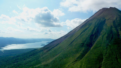
Located about 60 mi/100 km northwest of San Jose, Arenal National Park encompasses a large area in northwest Costa Rica.
Although Arenal is now dormant, it was one of the country's most active volcanoes for 43 years after a surprise eruption in 1968 and was of the most impressive sights in the country.
Near the volcano is a series of mineral baths that are part of Tabacon Hot Springs, a resort complex with eight swimming pools. (It welcomes day visitors as well as overnight guests.)
Lake Arenal is just west of the volcano, with fishing, hotels and, at the western end of the lake, windsurfing. In fact, some rate it as a world-class spot for the sport because of the strong and constant winds. The vistas are fantastic; many hotels have both lake and volcano views.
Although it's only 20 mi/30 km (as the crow flies) from Arenal Volcano to Monteverde Cloud Forest Reserve, the indirect roads and bus connections take the better part of a day. If you're not driving, it's possible to travel via a more direct route by taking a boat across Lake Arenal. Combined service by Jeep, motorboat and then taxi cuts the trip even more.
Overview
Introduction
Sparkling in the sun, Arequipa is called the White City because of the sillar, a white volcanic stone that makes up its buildings, modern ones as well as Spanish colonial. Peru's second-largest city sits surrounded by towering mountains—including the 19,000-ft/5,800-m volcano El Misti.
The city itself is the home of the monastery of La Recoleta (with a museum and library) and several interesting churches, but its highlight is the Santa Catalina Convent. Built in the late 16th century (but closed to the public until 1970), it was a self-contained community, a place where nuns could worship and live without leaving the convent. Walk through the well-preserved structure, soak up the peaceful atmosphere and discover the tiny, secluded plazas and lovely courtyards within.
From Arequipa, take a guided tour of Colca Canyon, one of the deepest canyons in the world (10,500 ft/3,191 m deep). (Day trips are possible, but they require many hours in a bus and are not recommended; two- or three-day trips are preferable.) Several local agencies arrange two-day trips with pleasant overnights in rural hotels. A journey to the canyon offers a view of extensive pre-Incan and Incan agricultural terracing, some of which is still farmed today, as well as a chance to see Andean condors at Cruz del Condor, a lookout point.
Adventurous travelers can follow in the footsteps of the chasqui, the Incan foot messengers, and trek the canyon. The Cotahuasi Canyon is more remote than the Colca, but it is the deepest in the world, with stretches as low as 10,857 ft/3,300 m. It is located 125 mi/200 km northwest of Arequipa. Or visit the Reserva Nacional de Salinas y Aguada Blanca, a nature reserve with stunning lakes and salt flats, located high in the surrounding mountains. The area is about 465 mi/750 km southeast of Lima by air. By road, the distances are closer to 625 mi/1,000 km.
Overview
Introduction
Many of the scenes from Roberto Benigni's Oscar-winning film La Vita e Bella (Life Is Beautiful) were filmed in charming Arezzo, Italy.
The churches and their works of art are what keep this Tuscan hill town on the map, but Arezzo also has several fine museums.
Overview
Introduction
Near the Ukrainian and Hungarian borders, Baia Mare is a bit off the beaten track, but if time permits, plan two days to see it and the surrounding area. Baia Mare is the center of the mountainous Maramures region, which is noted for its fascinating folklore and small villages, where the residents still live rural lives, working chiefly as farmers, weavers and woodcutters.
The city is a mix of very old and very new: It has more than its share of concrete apartment blocks and smoke-belching chimneys, but it's also home to the 14th-century Stefan the Great Tower (notice the clock), the Museum of Mineralogy, the Museum of Popular Art and Folklore, chestnut orchards and the ruins of the old city walls (only the Butcher's Tower still stands).
Be sure to drive 45 mi/75 km north to Sapinta to see the local cemetery—it's one of the most fascinating displays of folk art in all of Europe. The wooden grave markers are carved and painted showing the deceased doing what he or she did in life: a shepherd tending sheep, for example. If the person died a violent death, that, too, is portrayed. Beneath the portraits are humorous poems (the graveyard is known as the merry cemetery). Also plan to visit some of the area's famous wooden churches. You'll find fine examples in Birsana, Desesti, Ieud and Rogoz. Baia Mare is 250 mi/400 km northwest of Bucharest.
Overview
Introduction
The town of Gulf Shores anchors the section of Alabama's Gulf Coast that lies east of Mobile Bay. This beautiful strip of snow-white beach rivals Florida's Emerald Coast, and there are several places along the shore that can be enjoyed. Gulf State Park has a resort inn, campsites and cottages, and activities include golf, tennis and fishing (from an 825-ft/252-m pier). Learn about the area by visiting two museums depicting the history of the area, Gulf Shores Museum (phone 251-968-1473) and the Orange Beach Indian and Sea Museum (phone 251-981-8545). Nearby Fort Morgan State Historic Site (phone 251-540-5257) preserves what was a Confederate stronghold during the Civil War. The fort was active through World War I and displays an artillery gun from 1918. If you are at Fort Morgan State Park in the spring or fall, take part in bird banding with the Hummer Bird Study Group. Banding takes place on the beach from dawn until midafternoon (phone 205-681-2888; http://www.hummingbirdsplus.org). Bon Secour National Wildlife Refuge, which includes more than 7,000 acres/2,8330 hectares of territory, has been set aside to preserve the plant and animal life found in the coastal region (phone 251-540-7720. http://www.fws.gov/bonsecour). Follow the extensive nature trails to see hundreds of species of birds, or ride down Gator Lake to see its occupants. Horses can be rented for rides on the beach.
West of Gulf Shores is Dauphin Island (pronounced DOFF-in), Alabama's only barrier island. It's also home to another important Civil War fortress, Fort Gaines. (You can take a half-hour ferry ride across Mobile Bay to travel between Fort Morgan and Fort Gaines on Mobile Bay Ferry. Phone 251-861-3000; http://www.mobilebayferry.com.) There's a re-creation of an 1862 Confederate Christmas at the fort each December. Also on Dauphin Island is the Estuarium, which presents the ecology of the local environment, with interactive exhibits and two dozen tanks holding everything from oysters to octopi and baby alligators (phone 251-861-7500; http://estuarium.disl.org). The area is also a popular place for bird-watching, especially during spring migration. As part of the Alabama Coastal Birding Trail, the Audubon Bird Sanctuary (164 acres/65 hectares) lists about 345 different species of birds (phone 251-861-3607). Dauphin Island is also a good place to lie back on the beach and catch some rays.
North of Gulf Shores, Daphne is home to the American Sport Museum and Archives (phone 251-626-3303. http://www.asama.org). With more than 1,000 pieces in the collection, it is one of the largest sport art collections in the world. The artists' town of Fairhope (A few miles/kilometers south of Daphne) has a thriving downtown and lots of bed-and-breakfasts. The town draws more than 200 national artists with an annual arts-and-crafts festival in March. Fairhope is also near the Weeks Bay National Estuarine Research Reserve, one of about two dozen estuaries in the U.S. that are under federal protection. Phone 251-990-5004. http://www.weeksbay.org.
Just a few miles/kilometers south of Fairhope, you'll find Point Clear, best known for its historic Point Clear Marriott Resort, which served as a Confederate Hospital during the Civil War. There is a Confederate cemetery on the grounds, which were used as a training area for the Marines during War World II. The Bay area and Eastern Shore is 275 mi/440 km south of Birmingham.
Overview
Introduction
A large wilderness area extending into Tennessee and Kentucky, Big South Fork is a must for white-water enthusiasts as well as admirers of scenic beauty. The Blue Heron area contains a drive to the overlook of Devils Jump, and the Big South Fork Scenic Railway also runs through the area. The railway takes you to the Blue Heron Mining Community, a fascinating re-creation of a Depression-era town and coal mine. Among the available activities in the area are canoeing, fishing, raft trips, hiking, horseback riding, camping, hunting, swimming and picnicking. While you're in the area, be sure to see Yahoo Falls, a 115-ft/35-m waterfall in nearby Whitley City. 85 mi/135 km south of Lexington.
Overview
Introduction
This large area of gorgeous lakes and rivers is managed by the U.S.D.A. Forest Service and lies along Minnesota's northeastern border with Ontario, Canada. One reason the waters remain unspoiled is that most of the territory is off-limits not only to motorized vehicles of all kinds but also mechanized vehicles (meaning not only no motorboats or snowmobiles but also no bicycles, sailboats or paddleboats). Boats with small motors are allowed on some lakes but primarily to ferry canoes and kayaks to the more remote areas.
The majority of the wilderness has no power or telephone lines and no roads. Because the many lakes and rivers are connected or separated only by short portages, it's possible to travel great distances by water. (There are some 1,500 mi/2,415 km of canoe and kayak routes.) You can even cross the border to the adjoining Quetico Provincial Park in Ontario, Canada. In addition to canoeing and kayaking, you can enter the area on foot in the summer and by snowshoe and cross-country skis in the winter.
The number, size and variety of fish (including smallmouth bass, walleye, northern pike, perch, lake and rainbow trout) make the area an angler's paradise. Wildlife roaming the woods includes moose, black bears, deer, beavers, eagles and the common loon, Minnesota's state bird. And then there are wolves—the largest population in the lower 48 states—though they're not easily seen. There is an exceptional sense of solitude and quiet that comes with a place that's so far removed from civilization.
To experience it, you may have to rough it—camping, much of it in undeveloped sites, is the only accommodation within the wilderness area. If you'd rather have a roof over your head, you might want to stay in a lakeside resort. Many are found near Ely, which is the principal gateway to the wilderness area. Also in Ely is the International Wolf Center. The highlight is a pack of gray wolves that resides in a forest habitat at the center. https://wolf.org.
If you want to make an extended canoeing or kayaking excursion into the waters, it's best to use an outfitter: They provide boats, meals, permits and valuable guidance in planning your trip. Employing a guide to accompany you may also be a good idea. The largest number of outfitters and guides are based in Ely. There are others in Crane Lake and along the Gunflint and Sawbill trails (Highways 12 and 2). Arrange your trip in advance, especially if you plan to go late July-early September, when the area is busiest.
Wilderness permits are required for all who enter the Boundary Waters Canoe Area Wilderness. For overnight trips May-September, you'll need a summer quota permit, which should be reserved in advance from the BWCAW Reservation Center. If you're making a day trip or if your overnight trip takes place October-April, you can obtain a self-issuing permit at the entry point. https://www.recreation.gov/permits/233396.
The Boundary Waters Canoe Area Wilderness is part of the larger Superior National Forest, an area of 3 million acres/1.2 million hectares. The forest areas outside Boundary Waters offer some of the same scenery and wildlife but they're generally more accessible by car and motorboat. Permits are required for backcountry travel in the national forest. Contact forest headquarters in Duluth for more information. Phone 218-626-4300. https://www.fs.usda.gov/superior.
Overview
Introduction
Bridger Bowl Ski Area, one of Montana's most popular slopes, lies 16 mi/26 km northeast of Bozeman. There are 1,800 acres/728 hectares of skiable terrain, including an additional 400 acres/161 hectares in the Slushman's area. Bridger Bowl has 71 runs, the longest measuring 3 mi/5 km.
The resort's Ridge area is geared for adventurous, expert skiers, and includes rock cliffs and chutes (getting there requires a long hike above the nearest ski lift). On the other hand, Bridger's long, gentle slopes will appeal to less experienced downhillers and snowboarders (60% of the runs are designed for beginner and intermediate levels).
Overview
Introduction

Bucharest, Romania, the 500-year-old capital that was once touted as the Paris of eastern Europe, is undergoing changes as it breaks free from its past and joins other former Soviet-satellite capitals that are now part of the prosperous European Union.
Geography
Bucharest is situated in the Romanian Plain along the banks of River Dambovita, which connects with River Arges.
History
Romanian history has records saying that Bucharest was discovered and named by a shepherd named Bucur. Bucharest in Romanian means "joy." There is no proper documentation as to when the city was discovered. However, recent archaeological discoveries prove that the city could have existed during the prehistoric period, more than 150,000 years ago.
Bucharest became the capital of the Moldavian and the Walachain region in 1862. Consequently, the city witnessed rapid progression in economic growth in 1878.
Bucharest's population in 1918 was 382,853; it had expanded to 870,000 two decades later. There were major developments in all sectors including finance, transport, medicine, and education in the 1930s. Thus Bucharest earned the nickname "The Little Paris."
Potpourri
Typical Romainan folk music called doina is part of all local music events. An amazing blend of traditional Romanian and Middle Eastern music, doina is an integral part of Romanian peasant music. Klezmer and Lautareasca music are also a part of doina.
The Romanian words "doina" and "dor" have no equivalent words in any other international language. Dor means "to miss someone."
Romania is the only European nation where a few of the almost-extinct species of brown bears still exist.
Location
Bucharest serves as the departure point for many river cruises, but there is not a port in the city. The closest places for cruise ships to dock are Giurgiu and Oltenita or across the border in Bulgaria.
Overview
Introduction
This compact town near the Burundi border was the administrative capital of Rwanda in the colonial era, although it was renamed Astrida in 1935 following the death of the young Belgian Queen Astrid in a car accident. It reverted to the name Butare after independence and was officially renamed Huye in 2006.
Located 90 mi/150 km south of Kigali, it remains the site of the country's most important university and its most impressive cathedral. The city is also something of a repository for art-deco and other colonial-era architectural styles. Huye's premier attraction is the superb National Museum of Rwanda, which opened in 1988 and contains several fascinating displays of photographic collections relating to the precolonial era. A worthwhile excursion is to the former royal capital of Nyanza, which lies on a hilltop reached via a 45-minute drive north of the city center.
Overview
Introduction
The undisputed windsurfing and kiteboarding capital of the Caribbean, Cabarete, Dominican Republic, a pleasant and vibrant north-coast resort, is also the Dominican Republic's liveliest resort by night. It draws a more eclectic crowd than other resorts, including a large contingent of backpackers and budget travelers.
Dozens of laid-back bars and restaurants spill shoulder to shoulder onto the main beach, which is one of four. Many hotels are dedicated to the extreme sports trade, and there are comparatively few all-inclusive resorts. The town is famous for its nightlife, but suffered greatly following passage of an executive order forcing most bars to close at midnight. The law was later rescinded, but the damage was done.
Parque El Choco, immediately inland of Cabarete, is centered on Laguna Cabarete and offers nature hikes, fabulous birding and caverns with pre-Columbian pictographs. To the visit the caves, a guide can be hired on-site for about RD$900. The Cordillera Septentrional mountains, inland, offer opportunities for mountain biking and other active adventures.
Overview
Introduction
Founded by King Herod around 25 BC to 13 BC to honor Caesar Augustus, the ancient town of Caesarea, Israel, served as the capital of the Roman province for nearly 600 years. Caesarea, located 55 mi/85 km northwest of Jerusalem on the Mediterranean Sea, is also where Peter baptized the first Gentile convert and where Paul was imprisoned for two years while awaiting trial in Rome. Today, the site offers the remarkably well-preserved remnants of an amphitheater, aqueduct, chariot racetrack and bathhouses.
Modern Caesarea was built on sand dunes in the late 1950s and has become one of Israel's most beautiful and exclusive resort towns. On weekends, the town is crowded with visitors. It's fun to drive through the tidy streets and take a peek at the splendid villas with their beautiful lawns and flower gardens.
Divers and snorkelers can swim over and through the ruins of the now submerged Roman port. There are ongoing excavation digs organized by the Combined Caesarea Expeditions, whose goal is to bring to light the underwater ruins of the harbor and the remnants of the ancient city. Restaurants and shops built overlooking these ruins have become local hot spots.
Plan to visit the Crusader city fortifications and the Roman aqueduct and amphitheater (the theater hosts musical, ballet and opera performances in the spring and summer). The city also boasts Israel's only 18-hole golf course, next to the luxurious Dan Caesarea Hotel.
Caesarea is an excellent place for children. The high-tech educational materials available on-site bring to life the long history of both the ancient port and, ultimately, Israel, which, because of its position as the gateway between east and west, has been conquered and captured more times than anyone seems to know.
The arid hills near Caesarea are well suited to wine production and are home to many of the country's vineyards and kosher wine producers. Several wineries offer tours of their cellars, and guides explain what exactly makes a wine kosher or not. Interestingly, those accounts often differ.
At the Tishbi Estate and Winery and Visitors Center, Golan Tishbi, son of the estate's founder, Jonathon Tishbi, makes a wine known for being ecofriendly in production and dissemination: Locals take empty wine bottles and olive oil jugs and fill them directly from Tishbi barrels. http://www.tishbi.com.
Fifteen minutes north of Caesarea lies the growing and prosperous community of Zichron Ya'acov. Founded in 1882 by Baron Edmond de Rothschild, Zichron Ya'acov is perched on hills overlooking the Mediterranean coast. The pedestrian-only main street is paved with cobblestones, adding to the country-style atmosphere. Art galleries, arts-and-crafts shops and good restaurants fill the town and draw a lot of visitors on Saturday.
The town's Carmel Wineries offers tastings and a guided tour. The Ramat Hanadiv Memorial Gardens on the road from Zichron Ya'acov to Binyamina house Baron Rothschild's tomb. The 20 beautifully landscaped gardens include a unique fragrance garden, designed with the visually impaired in mind.
Overview
Introduction
Although Chamarel village, 18 mi/30 km south of Port Louis, holds little of interest to the casual visitor to Mauritius, the nearby Terres de Couleurs (Colored Earths) make the trip well worth the effort. The name comes from the soil, which is layered in yellow, red, green, blue, purple and black. Also nearby are small, beautiful waterfalls. Overview
Introduction
The industrial city of Ciudad Juarez lies across the Rio Grande from El Paso, Texas, and 225 mi/360 km north of Chihuahua. The historic center is relatively safe, but the city has earned the unenviable reputation as the most dangerous city in North America, so if you go, make sure you stick to well-policed routes.
If you can push past the initial border-hopper zone, you'll find museums and markets that yield a less-distorted view of Mexico. Juarez has two centers of interest: the area around the markets and the one around Plaza de las Americas.
The market area goes on for blocks in every direction, with both stalls and stores specializing in everything from produce and meat to bulk candy and potions for magical cures. There are also two adjacent cathedrals in the area, one very old and one new—both should be visited. A few blocks away is a history museum.
The area around Plaza de las Americas has an art museum (Museo de Arte) and, across the street, an excellent arts-and-crafts center (Centro Artesanal), where high-quality crafts from throughout Mexico can be purchased at reasonable prices.
Overview
Introduction
Located 130 mi/210 km northeast of Oklahoma City and long known as a health spa because of the artesian mineral wells in the area, Claremore is also home to the J.M. Davis Arms and Historical Museum, one of the largest of its kind, with thousands of firearms. https://www.thegunmuseum.com.
The area's most popular attractions, however, have to do with legendary humorist Will Rogers. The Will Rogers Memorial Museum in Claremore has dioramas and artifacts related to his life and career, as well as clips from his many films. Rogers' grave is located on the museum grounds. https://www.willrogers.com.
You can also visit Rogers' birthplace in nearby Oologah: The home has been preserved and filled with memorabilia.
The Will Rogers Stampede Rodeo takes place in June, and the Bluegrass and Chili Festival is held in nearby Wagoner in early September.
Overview
Introduction
The spectacular gorge of the Columbia River forms the border between Oregon and Washington. The gorge is filled with high waterfalls, high dams and high winds. (To get a good overview of all there is to see and do in this region, cross the river into Washington and visit the Columbia Gorge Interpretive Center near Stevenson.) The gorge extends for a long distance, but we think the section of the river that slices through the Cascades, from about The Dalles to just east of Portland, is the prettiest. The best views in the gorge are from the Vista House at Crown Point or from the Bridge of the Gods at Cascade Locks.
The best way to experience the gorge is either to venture off onto one of the many hiking trails (especially the moderate 2-mi/3-km climb to Angels Rest) or to drive the awe-inspiring (and sometimes terrifying) Historic Columbia River Highway—no RVs allowed. To reach the highway, exit off Interstate 84 about 6 mi/10 km west of Bonneville Dam. The road was an engineering marvel in its day, and every turn offers gorgeous view of the gorge. Highlights of the drive include Oneonta Gorge, Horsetail Falls and Wahkeena Falls. If you can see only one cascade, though, make it Multnomah Falls, which is more than double the height of Niagara.
By far our favorite dam to visit along the Columbia River is Bonneville Dam. It has everything from a fish hatchery to underwater windows for watching fish navigate the dam's ladders. We highly recommend a stop. Also worth visiting is the Columbia Gorge Discovery Center in The Dalles. There, you can learn the history of The Dalles Dam and of the spectacular waterfalls and ancient fishing grounds that were flooded once the dam was completed. The spectacular stretch of the Columbia near Hood River is considered one of the windsurfing capitals of the world—steady breezes provide ideal conditions for windsurfing and the increasingly popular sport of kiteboarding.
In late 2017, the Eagle Creek fire tore through the region causing enormous damage to more than 48,000 acres of pristine wilderness. Many of the trails were quickly repaired, but historic structures such as Benson Bridge were destroyed. Regardless, while the Douglas firs may now be gone, the fire has revealed interesting basalt cliffs and rock formations. Multnomah Falls (at 620 ft/190 m, it's the highest falls west of the Rockies) marks the entrance to the park.
The fire didn't damage the trails on the Washington side of the Columbia River, which will undoubtedly become a popular alternative for hiking in the gorge. The pastoral fruit orchards and vineyards on the "Fruit Loop" to Mount Hood were likewise unaffected. http://www.visitcolumbiarivergorge.com.
Overview
Introduction
Encompassing a scenic stretch of Ireland's west coast, County Clare holds several of western Ireland's foremost natural attractions. Beginning at the northern edge of the county (near Galway) is the Burren, a vast expanse of limestone that has an almost lunar look. It's dotted with dolmens (ancient rock tombs), ring forts, cairns and early Christian ruins. Soil collects in long cracks in the limestone and supports plants from an incredible diversity of regions—Mediterranean to arctic.
Many visitors first set foot in County Clare when they arrive at Shannon Airport. Nearby Shannon Town was built in the 1960s to house workers for the airport and surrounding industries. It has little to offer visitors, who generally head for Limerick, Galway and beyond.
A better base for a visit to Clare is the county town of Ennis, a vibrant place with good restaurants, shops and lively music pubs. Traditional music has become popular all over the country, but Clare has long been one of Ireland's hotspots, thanks to small but famous music villages such as Doolin and Miltown Malbay. The instruments include the bodhran, the fiddle, the uilleann pipes and the tin whistle. It's worth seeking out this sort of authentic music, which is wild and fierce stuff that captures something essential about the Irish character.
A short drive south along the coast brings you to the Cliffs of Moher, the high seaside bluffs that turn up in every promotional brochure and travel video about Ireland.
You can also explore the smaller towns of Cratloe, a short distance east of Bunratty and surrounded by oak forests, or Killaloe, with its sixth-century cathedral.
Must See or Do
Sights—The Cliffs of Moher; The Burren; the Ennis Friary; Bunratty Castle.
Museums—The Burren Centre in Kilfenora to learn about the geology and flora of the unique region; Craggaunowen, an open-air museum that re-creates ancient Celtic dwellings.
Memorable Meals—Modern Irish cuisine at The Cloister in Ennis; Mediterranean fare at Rowan Tree Cafe & Bar; traditional Irish cooking at Town Hall Bistro.
Walks—The paths along the Cliffs of Moher; a walk along the beach at Lahinch.
Overview
Introduction
Delaware is a little short on land, but it's long on water—much of it borders the Atlantic Ocean. As a result, its southern beaches and beach towns are a big draw. All have sand and sea, but they are remarkably varied, ranging from tranquil stretches of protected shoreline to low-key resort towns to busy vacation centers such as Rehoboth Beach.
There are some interesting things to do away from the water, as well. Northern Delaware has a strong list of cultural attractions, including the remarkable Winterthur Museum in the Brandywine Valley, one of several attractions initially owned by the du Pont family.
Given its compact size and many things to see, Delaware can provide travelers with a lot of activities in just a few days' time. Those with a week or more will find the Delaware shore a relaxing place to linger—or they might consider seeing the state as part of a larger tour that includes Pennsylvania, Maryland, Virginia and New Jersey.
Geography
Delaware shares a peninsula with the eastern edges of Maryland and Virginia (creating the peninsula's regional name Delmarva). It's a flat state for the most part, with some rolling hills in the north. The entire eastern border of the state lies along the water, including 25 mi/40 km of Atlantic coastline. It also claims the distinction of having the fewest counties—three in all (New Castle, Kent and Sussex)—of any state in the union, although it is the second smallest in area, after Rhode Island.
History
The Lenni-Lenape tribe, also known as the Delaware, lived along the shores of Delaware Bay before Europeans arrived. The tribe's domain extended into parts of New Jersey and eastern Pennsylvania. In winter, they gathered in longhouses, and in summer, the tribe cultivated corn in its hunting and fishing camps.
Henry Hudson was the first European explorer to see Delaware, and he claimed the territory for the Dutch in 1609. The first Dutch settlers were massacred by the Native Americans soon after establishing a settlement near present-day Lewes in 1631. Swedish immigrants were the next to try their luck, founding their New Sweden colony near present-day Wilmington. The Dutch later took control of the Swedish settlement and struggled against the British for control of the area. The British finally won out in 1664, and Delaware eventually fell under the rule of Pennsylvania. However, by 1704, the Delaware colonists had established their own legislature.
The state had a significant impact on the development of the U.S. when, in 1776, Delaware's Caesar Rodney cast the deciding vote for the Declaration of Independence. In 1787, Delaware representatives were the first to ratify the U.S. Constitution, which is why the state's nickname is The First State.
With a highly developed infrastructure of canals and waterways and ample power from its many waterfalls, Delaware was one of the first states to support heavy industry. Today, cities such as Wilmington and Dover still thrive on chemical processing and manufacturing (agriculture is practiced mainly in the state's southern half). Also, Delaware's industry-friendly banking laws have drawn many major banks to set up credit-card operations there. The lack of a state sales tax also makes it attractive to visitors.
Snapshot
Delaware's main attractions include beaches, historic sites, architectural restorations, museums, art galleries, bicycling, the Brandywine Valley, car and horse races, the Winterthur Museum, gardens, fishing, watersports and tax-free shopping.
Travelers interested in beaches and watersports will find them primarily in the southern half of the state. Those looking for history, museums, city life, architecture and outdoor recreation may prefer the northern section. Travelers who seek wide-open spaces, however, may find the state less to their liking—it's only 96 mi/154 km long and no more than 35 mi/56 km wide.
Potpourri
Just slightly more than 11 mi/18 km long, the Delaware Turnpike (the section of Interstate 95 that crosses the neck of Delaware between the Delaware Memorial Bridge and the Maryland state line) is part of a stretch of I-95 dedicated by former U.S. President John F. Kennedy just a week before his assassination.
The Mason-Dixon Line, the traditional dividing line separating the North and South that is usually thought of as running east and west along the border between Pennsylvania and Maryland, actually turns in a north-south direction to designate the major part of the boundary between Delaware and Maryland. Mapped by 18th-century English surveyors Charles Mason and Jeremiah Dixon, it extends from Pennsylvania to Delaware's southwest corner, where it meets the Transpeninsular Line that forms Delaware's southern boundary with Maryland.
Delaware played a significant role in the Underground Railroad, with at least three routes weaving through the state. Led by Harriet Tubman, many slaves escaped along these routes. Woodburn, the present-day Governor's Mansion, is rumored to have been a stop.
The town of Laurel, in southwestern Delaware, has more than 800 Victorian houses—most in pristine condition.
Delaware seems to have its fair share of ghosts: This first occupant of what is now the Governor's Mansion was known as a heavy drinker. His spirit reportedly wanders at night finishing up any wine left in glasses. Fiddler's Hill, southwest of Lewes, is said to be inhabited by the spirit of a young musician. Some claim that his playing can still be heard on certain nights.
Because of their valiant battlefield actions during the Revolutionary War, Delaware troops became known as Blue Hen's Chickens, an allusion to the fierce fighting cocks mothered by blue hens. The nickname was later given to all residents of the state.
Prior to manufacturing such products as nylon, cellophane and Teflon, the chemical giant DuPont Co. manufactured gunpowder. E.I. du Pont, who emigrated to the U.S. after the French Revolution, earned some of his fortune by selling gunpowder during the War of 1812.
The movie Dead Poets Society, starring Robin Williams, was filmed at St. Andrew's prep school in Middletown.
Delaware is named after Sir Thomas West, otherwise known as Lord de la Warr. He was a leader of the Jamestown settlers and governor of Virginia in the early 1600s and led the campaign against the Powhatan tribe.
Overview
Introduction
This Delaware River town, 13 mi/20 km south of Wilmington, is the gateway to Fort Delaware State Park. Located on Pea Patch Island, the park is only accessible by boat—ferries depart on a regular basis.
The fort, which is surrounded by a moat, was used as a prison during the Civil War. Today it is a living-history museum with costumed interpreters.
Overview
Introduction
Located about 85 mi/135 km south of Wilmington, Delaware Seashore State Park covers two peninsulas on both sides of Highway 1 between Dewey Beach and Bethany Beach. The 6-mi/10-km beach has plenty of parking, changing rooms, showers and a snack bar. Rafts, beach chairs and beach umbrellas are available for rent.
The park is open year-round, although some amenities are only available from Memorial Day to Labor Day. https://destateparks.com/beaches/delawareseashore.
Overview
Introduction
Beautiful views are in store for visitors to the city of Delaware Water Gap and the Delaware Water Gap National Recreation Area. It offers river recreation and fetching ravines.
Straddling easternmost Pennsylvania and westernmost New Jersey, the 70,000-acre/28,400-hectare park is home to waterfalls, wildlife, fossil beds, streams, ponds and native vegetation, in addition to an environmental education center. Dingman's Falls Nature Trail is accessible to visitors with disabilities.
Overview
Introduction
Ferghana is an imperial town with a decidedly Russian-czarist flavor—it was founded in 1877 as a newer, Russian counterpart to nearby Marghilan. Many of its buildings date from the late 1800s and early 1900s. There are a couple of decent hotels in town, which make it a good base for exploring the Ferghana Valley. Before traveling to the city of Ferghana, or anywhere else in the Ferghana Valley, check on the current political situation. About 125 mi/200 km southeast of Tashkent. Overview
Introduction
With the discovery of gold in the foothills east of Sacramento, California's destiny took a dramatic turn in the late 1840s. The California gold rush was on, and the area was invaded by the "forty-niners"—named for the year when most of them arrived. Today, the region has a number of museums and historic sites related to the gold-rush era. A few of them could be seen on a daylong excursion from Sacramento, but there is enough to see along Highway 49 to justify a leisurely weeklong trip (best in spring, when temperatures are balmy and the hillsides are abloom with wildflowers).
The first nugget of gold was discovered in 1848 at a mill owned by John Sutter. Today, a replica of the mill stands at Lotus County Park in Coloma, located 35 mi/55 km northeast of Sacramento. The Gold Discovery Museum at the park has displays about the gold rush and other aspects of the area's history.
Spending a day in the area around Nevada City, about 60 mi/97 km northeast of Sacramento on the northern boundary of Gold Country, will give you an idea of the world that gold built. Nevada City is the most authentic gold town in the area, with its gas streetlights and Victorian buildings. Two sites not to miss are the National Hotel (said to be the oldest continuously operating hotel west of the Rocky Mountains) and the Malakoff Diggins State Historic Park.
The neighboring town of Grass Valley retains the flavor of its Cornish heritage (many of the miners were from the tin-and copper-mining areas of Cornwall, England). A handful of the restaurants still serve the meat- and potato-filled Cornish pasties made from recipes handed down from their forbearers. An excellent collection of mining artifacts is on display at the North Star Mining Museum on the outskirts of town. And don't miss 785-acre/318-hectare Empire Mine State Historic Park in Grass Valley, the site of one of the richest and oldest hard-rock mines in the state. It closed in 1956.
For more Gold Country highlights, plan a trip along Highway 49, which connects most of the significant gold rush sights along a 400-mi-/645-km-long foothill corridor that extends to the Yosemite National Park area. Among places worth exploring: Old Town Auburn, on Interstate 80; Angels Camp, which inspired Mark Twain's story The Celebrated Jumping Frog of Calaveras County (it holds a jumping-frog contest the third weekend in May); Jamestown, where you can still pan for gold; Coulterville, virtually unpocked by progress, where Main Street is listed on the National Register of Historic Places; and Mariposa, a gateway to Yosemite.
The star billing, not to be missed, goes to Columbia State Historic Park, the Gem of the Southern Mines, where High Noon was filmed. This pedestrian-only park, located in California's Mother Lode, preserves a gold mining town in its entirety and is staffed with docents dressed in period costume. http://www.visitcolumbiacalifornia.com.
Overview
Introduction
Located in Zimbabwe's lowveld region of baobab trees, scrubland and spectacular sandstone cliffs, Gonarezhou is a remote national park infrequently visited by international tourists. Zimbabwe's second-largest river, the Save, flows through it, and where it joins the Rundu River within the park's boundaries is Zimbabwe's lowest elevation point. Facilities are very basic (mostly camping), the roads are in a poor state, and four-wheel-drive vehicles are a necessity. However, the park will appeal to those who like isolation—it's really off the beaten path.
Be cautious when visiting Gonarezhou: The elephants, rhinos and buffalo in the park are more likely to charge humans than in other parks because these species have been heavily hunted and poached in the area. Understandably, they appear to hold something of a grudge against humans. The park has the highest variety of birds in Zimbabwe, and the bird count often reaches more than 400 species. Gonarezhou is now part of the 13,514 sq mi/35,000 sq km Great Limpopo Transfrontier Park, which links the Kruger National Park in South Africa and the Parque Nacional do Limpopo in Mozambique. Animals can move freely between these three sanctuaries as there are no longer any fences separating them. The park is 265 mi/430 km south of Harare.
Overview
Introduction
The word chaco means "abundance of wildlife," and the Gran Chaco more than lives up to its name. Spotting conditions are ideal for nature lovers and anglers; comforts, however, are minimal if not nonexistent. Be forewarned that a trip to this region tends to have some rugged aspects—only adventurous travelers with a strong interest in fishing, photography and nature will enjoy it. The 248-mi/400-km Trans-Chaco Highway allows overland travel through the Chaco to Brazil. Take along plenty of insect repellent. If you're staying overnight, take along a mosquito net and a supply of water. And do be sure to look at the stars if you visit the Chaco: The glare of city lights does not exist there. 320 mi/515 km north of Asuncion. Overview
Introduction
Zimbabwe's capital city, Harare is modern and pleasant. Originally called Salisbury after the then British Prime Minister, the Marquess of Salisbury, the city was founded in 1890 by Cecil Rhodes' British South Africa Company. It is dominated by a kopje—a hillock or pile of boulders, and it was from here that the colonial leaders surveyed the surrounding open plains and decided that this was a good place for a settlement. On 13 September, the Union Jack was raised on a spot that became Cecil Square (later known as Africa Unity Square after independence), and a 21-gun-fire salute was made to Queen Victoria. During the second anniversary of Zimbabwean independence in 1982, the city's name was changed to Harare. This was derived from the Shona chieftain Neharawa, who lived in the area before the colonials arrived.
Today, Harare has an easygoing charm, and the city is not as bustling and hurried as a metropolis such as Nairobi, Kenya, and we are thankful for that. The central business district is a neat grid of modern office blocks, intercepted by some older colonial buildings, and the broad streets are lined with flowering trees. There isn't a great deal to see and do—in fact, you can visit the highlights in one full day. But add another if you want to slow the pace and do some shopping. Harare has the country's best restaurants and several short excursions can be made from the capital.
Overview
Introduction
With walls rising 7,900 ft/2,400 m from the canyon floor, Hells Canyon, Idaho, is one of the deepest gorges in North America—even deeper than the Grand Canyon. It's located on the Snake River in western Idaho, between Boise and Lewiston. Nature lovers can spend weeks there; others just see it in passing.
There is road access to the river in several places, though some routes may only be open in the summer and early fall. Two that are usually open year-round are Highway 71 to Hells Canyon Dam (well worth seeing) and the gravel road to Pittsburgh Landing.
The most impressive views of the canyon are from the river itself. The adventurous can raft down the river, but a quicker—and drier—way to see the area is to take a jet boat. Various river adventures can be booked at Lewiston (on the Idaho-Washington border 200 mi/320 km north of Boise), a popular gateway to Hells Canyon. Outfitters also depart from nearby Hells Canyon Dam and Hells Gate State Park.
Lewiston has the distinction of being an inland seaport: It ships goods down the Columbia River to the Pacific. It offers a day's worth of attractions, including the Luna House, a museum devoted to the activities of Native Americans and pioneers in the region.
While in the area, be sure to see the 9,000-ft-/2,750-m-tall mountains in the Seven Devils Range (access is from Highway 95 near Riggins), some of the state's most dramatic scenery. In the Seven Devils Wilderness Area, backpackers can enjoy a vast system of trails and more than 30 alpine lakes.
Those interested in Native American history and culture should check out the headquarters of the Nez Perce National Historic Park in Spalding (15 mi/25 km east of Lewiston). Park displays document the battles and exodus of the Nez Perce people in the 1870s. The park consists of dozens of sites in Idaho, Washington, Oregon and Montana (you'd need several days to see it all). The visitors center, which has a fine collection of Nez Perce artifacts, is the place to plan your tour of the other sites.
Hells Canyon is great for camping, relaxing and fishing, but it's an undeveloped area. If you're driving, check road conditions prior to entering.
Overview
Introduction
This incredibly deep canyon—its walls rise 7,900 ft/2,400 m from the floor—was formed by the Snake River. Outdoor enthusiasts go there for white-water rafting, fishing and the extremely rugged landscape. Access to the area is not easy, however. There are a number of lookout points on the Oregon side of the canyon (the Snake forms the Oregon-Idaho border). Several of them are seen by taking the road out of Imnaha: At the end of the road is the precipitous Hat Point Overlook. The Hells Canyon Overlook is reached by taking Highway 86 east out of Baker City and then by picking up forest roads 39 and 3965. If you continue on Highway 86, you can cross the river at the Oxbow Dam and then continue to the Hells Canyon Dam. (Check road conditions before you undertake these drives, and be aware that some areas will be impassable in the winter and spring.)
The most impressive views of the canyon are seen by taking a boat trip on the river. The adventurous can raft or kayak down the Snake, while others can take a jet-boat tour that leaves from Lewiston, Idaho. 305 mi/490 km southeast of Portland.
Overview
Introduction
This wonderland of scenic gorges, sparkling waterfalls and breathtaking views will eliminate once and for all the notion that the Midwest is only monotonous farmland. This area in the southeastern corner of the state is a great place for bird-watching, with some 100 different species in the area, as well as for rock climbing and rappelling.
A must-see attraction is Hocking Hills State Park. Be sure to visit Ash Cave (more an amphitheater than a cave, with a small waterfall). Stand on top of the waterfall or sit on one of the "benches" underneath the falls—refreshing in the summer and an icy wonderland when temperatures dip below freezing. Also check out Cantwell Cliffs (surprisingly rugged), Cedar Falls (at the head of the gorge of Queer Creek), Old Man's Cave (waterfalls and caves) and Rock House (a strange cottage built into the cliff face). If you plan to visit a few caves, spend the night in the park. However, do not explore unfamiliar surroundings at night, as flat forest ground can quickly turn into a 40 ft/12 m drop. In the fall, the park is a great place to see the changing foliage, and if you're planning to go in January, you should make reservations for the Hocking Hills Winter Hike. The annual event takes hikers on a tour of frozen waterfalls, crystalline streams and fantastic ice bridges. The Hocking Hills Scenic Railroad, based in Nelsonville, is a train ride powered by a restored steam locomotive. The area offers a number of small shops that carry items made by local artists. Hundreds of rentable cabins are tucked away among the hilly landscape, many with fireplaces and private hot tubs on outdoor decks. It's a perfect way to watch for nocturnal wildlife when there's a full moon. If you like something a little more palatial, you might want to book a fantasy room at Ravenwood Castle. Or for a unique night, ask to stay in one of the gypsy wagons instead. 150 mi/240 km southwest of Cleveland.
Overview
Introduction
Jackson Hole, Wyoming, is the name of the mountain valley extending almost 50 mi/80 km along the east side of the Teton Range from the town of Jackson to near the southern border of Yellowstone National Park and including several towns: Jackson, Kelly, Moose, Moran and Teton Wilson.
The Jackson Hole Mountain Resort hosts several hundred thousand tourists a year. Visitors go to enjoy the endless miles/kilometers of forest and ranch land to the east and south, the scenery, the many recreation options and the wildlife. Jackson Hole has also become one of the destinations for celebrity and politician sightings.
Jackson Hole retains much of its historic cowboy heritage despite the development boom, and visitors have a wealth of options, from exhilarating white-water rafting trips, pristine hiking trails, impeccable service and gourmet cuisine to manicured golf greens, black-diamond ski runs and honky-tonk bars.
Unless you visit in the off-season, lodging in the area will be expensive, but a little research (or opting to camp) can make the trip more affordable. It also will leave you with more money to spend on shopping and activities: In between skiing, fishing, hiking and just taking in the view of the Teton mountain range, many people spend a couple of days wandering through the area's wealth of galleries, as well as brand name and specialty shops in downtown Jackson and outlying areas.
As a resort area, Jackson Hole has widely varying numbers of tourists throughout the year, and many businesses alter their hours accordingly, either shortening hours or closing for stretches during less busy times. It's also not unusual for restaurants and bars to close for private parties. Unless specifically noted, all hours listed in this guide are for summer, which is the busiest season when most businesses are open. However, it is always a good idea to call ahead to confirm opening hours before making plans.
Must See or Do
Sights—Mountaintop views from the top of Snow King Resort or Jackson Hole Mountain Resort; Grand Teton National Park; a winter sleigh ride through the National Elk Refuge.
Museums—Impressive images of nature at the National Museum of Wildlife Art; cowboy and ranching history at the Jackson Hole Historical Society and Museum; local artists on view at the Center for the Arts.
Memorable Meals—Wild Sage's innovative treatment of game in an elegant setting; a four-course meal by a double fireplace at Snake River Grill.
Late Night—Dance and straddle a saddle barstool at the Million Dollar Cowboy Bar.
Walks—Any trail in Grand Teton National Park, and many throughout the surrounding mountain ranges.
Especially for Kids—Snow King Alpine Slide; the Jackson Hole Shootout
Geography
The town of Jackson is the southern anchor of Jackson Hole, south of Grand Teton National Park and just east of the Idaho border. It sits in a valley surrounded by the Hoback Range and Snow King Mountain to the south, the Gros Ventre Mountains to the east and the spectacular peaks of the Teton Range to the north and west. The Snake River runs to the west between Jackson and Teton Village.
The town center is flat, making walking an excellent option, and areas on the edges of town creep up the mountainsides and buttes.
To the west are the small town of Wilson and the road leading to Teton Village, home of Jackson Hole Mountain Resort and a spectacular array of dramatic vacation homes.
History
Jackson Hole and the Tetons were created by geological forces over the course of 10 million years. The valley was home to elk herds and several groups of Native Americans—Shoshoni, Crow, Blackfeet, Bannock and Gros Ventre (pronounced grow vaunt)—before American and European fur trappers discovered it in the early 1800s.
Originally called Jackson's Hole, the area was named for early mountain man David Jackson. (The word hole was a common term used at the time to describe a valley surrounded by mountains.)
Trappers and mountain men had the valley to themselves until the Homestead Act of 1862 brought a few more settlers. Most were not prepared for the brutal winters, and lack of access to railroads or decent roads, for that matter. They quickly sold out, enabling hardier souls to create large cattle ranches that were marginally successful. By 1880, Jackson Hole had 23 residents: 20 men, two women and one child.
By the 1900s, as word of the beauty of the mountains spread back east, visitors started to appear, and ranchers and cowboys became guides and outfitters to help tourists safely experience the valley. Ranchers continued to raise cattle and work the land, but the tourists kept arriving—bringing a welcome influx of money into the struggling local economy. By the 1920s, Jackson was a thriving frontier town, and dude ranches were common.
As Grand Teton National Park was established to the north, controversy over land use grew. Local ranchers wanted the freedom to control the land and the area's development. At the same time, there was a national push (backed by John D. Rockefeller Jr., who was quietly buying up land) to preserve the area for its beauty and importance to the greater Yellowstone ecosystem.
Tourism has continued to grow, and it is now the region's primary industry.
Potpourri
The country's first all-woman city council was elected in Jackson in 1920, the same year that the 19th Amendment was finally passed giving women the right to vote.
On board the US Voyager II is an Ansel Adams photograph of Jackson Hole. The spacecraft, launched in 1977 to explore distant parts of our solar system, is more than 14 billion mi/22.5 billion km from the Earth. Its cargo contains photos and other objects that best represent our planet in the event that it is ever found by intelligent life forms.
Jackson's elk-antler auction is one of a kind. Each year, local Boy Scouts collect antlers that have been shed in the Elk Refuge. The antlers are auctioned on the Saturday one week before Memorial Day, with most of the proceeds used to fund the feeding program at the refuge.
The Jackson Hole Airport is the only commercial airport within the boundaries of a national park.
Celebrity sightings have included Sandra Bullock eating at a local barbecue joint, Uma Thurman making her way down the slopes at Jackson Hole Mountain Resort and Tiger Woods scoping out property with Teton views. The area's most famous resident, Harrison Ford, has donated his private helicopter for use in search and rescue missions. He even flew one of those rescue missions himself.
More than 15 feature films have been made on location in Jackson Hole, including Django Unchained, Rocky IV and The Big Trail, featuring John Wayne in his first movie role. Sitcom Modern Family is one of the more recent TV shows to use the Tetons as a backdrop.
Overview
Introduction
The county town of Kildare, Ireland, is set in the heart of the Curragh, the huge, grassy limestone plain 30 mi/48 km southwest of Dublin where Ireland's famous racehorses are bred. Its main attraction is the Irish National Stud on the outskirts of town, where in 1900 Colonel William Hall-Walker used astrology and other unusual theories to produce a string of winners. He gave the facilities and horses to the state in 1943, and today owners from around the world breed and train their horses there. On the adjacent grounds (accessible with the same ticket) are the lovely Japanese Gardens and St. Fiachra's Garden.
In Kildare town, you can climb the round tower next to St. Brigid's Cathedral.
Overview
Introduction
Titicaca, the world's highest navigable lake, is a world unto itself—a definite must-see. It's located 560 mi/900 km southeast of Lima, on the Peru/Bolivia border, at an altitude of 12,500 ft/3,812 m. One way to see Titicaca is on the 12-hour train ride from Cuzco to Puno through the Andes, a trip that reaches an elevation of more than 14,000 ft/4,265 m as you pass by farms, people's backyards, waterfalls and bleak but wondrous scenery—clear blue sky, deep blue water and dry, barren landscape.
This is an expensive tourist train and runs three or four times a week; the local train, which was notorious for thievery, no longer operates. Tourist buses also cover this route, stopping at major sights en route. They are faster and have English-speaking guides. Peruvians and tourists on a time limit take normal buses between Cusco and Puno, usually a six-hour trip.
Don't neglect the attractions on the Bolivian side of the lake. Stop overnight in Puno, an uninspiring town near the border that's one of the best places in Peru to buy Andean handicrafts—alpaca sweaters, rugs, ponchos and tapestries. (The town is also known for its colorful fiestas and folk dances.) Then continue by bus or car to Copacabana, just across the border, for Bolivian customs formalities and to tour the cathedral or take a day trip to the Isla del Sol and Isla de la Luna. With its small-village atmosphere and charm, this town is a nice overnight stay from which you can see more of the lake.
From Puno, tours or public transport are available to Taquile Island (small Inca ruins and very nice woven goods), Sillustani on Lake Umayo (to see chullpas, the funerary towers of the ancient Colla people) and the Floating Islands (actually enormous floating reed mats that support the Uros people's villages of reed huts—you can buy reed souvenirs there).
Overview
Introduction
Gabon's third-largest city, Lambarene (pop. 30,000) is on an island in the Ogooue River, which is almost 0.5 mi/1 km wide at this spot. The town is closely associated with Dr. Albert Schweitzer—it's where he lived, worked and died. (A philosopher who recognized the need for better medical care in Africa, Schweitzer became a surgeon in his 30s and moved to Gabon. He was awarded the Nobel Peace Prize in 1952.) You can take a short trip by pirogue to the site of the famed humanitarian's home, grave and mission hospital, which is still in operation. A small museum at the hospital chronicles Schweitzer's life. A pirogue ride on the nearby lakes and lagoons can also be arranged to see hippos, crocodiles and beautiful birds. We suggest taking a half-day trip—shorter trips don't go far enough into the bush. 100 mi/160 km southeast of Libreville. Overview
Introduction
The northern third of Sweden is Lapland, the region that begins about 500 mi/805 km north of Stockholm and is home to the indigenous Sami people.
The Norrbottens Regional Museum in Lulea and the Silver Museum in Arjeplog have excellent displays about the life and history of the nomadic Samis. Reindeer are of utmost importance to the Samis—they provide food, tools and clothing for their shepherds and play a prominent role in their literature and myths.
Lapland is not as barren as most people think. With its forests, winding rivers and mountains, it is an excellent vacation area. There is skiing year-round (though it's not very good in the summer), great fishing, snowmobiling, hiking, dogsledding, moose safaris, reindeer sleigh rides and river rafting.
Those traveling with children will want to visit Lycksele, which has a theme park called Lyckoland (carnival-style boat and electric-car rides) and a zoo that allows visitors to have a close encounter with such northern animals as moose and lynx. http://www.lyckseledjurpark.com.
The summer sun is up till after midnight in June and early July (and so are the mosquitoes—take plenty of insect repellent). A good place to see the midnight sun is Kiruna, which is home to the world's largest mine still in use, called KLAB (http://www.kirunalapland.se), and Esrange, Europe's only civil rocket-launch station. Both sites can be visited with a guide, but tours must be booked in advance and can be cancelled upon short notice.
Don't be surprised if the town isn't exactly where you left it on a former visit. Kiruna is sinking into the mine, and every building in town is gradually being relocated northwest of its current location to the base of Luossavaara mountain.
Winter, which is unrelentingly dark, cold and often damp, is occasionally brightened by the aurora borealis (northern lights). Abisko National Park, in the region's far north, abuts Tornetrask Lake and provides good views of the northern lights. The park also offers a variety of winter sports opportunities as well as hiking in the warmer months.
In Jukkasjarvi (a few miles/kilometers from Kiruna) is the Ice Hotel. It is built each year out of ice, and guests sleep on slabs of ice, drink Absolut vodka from ice glasses, reflect in an ice church and watch plays in a replica of Shakespeare's Globe Theatre. https://www.icehotel.com.
The best way to tour Lapland is by car, though Sweden's high gasoline prices make this expensive. Trains and buses, which connect the main towns, are more economical.
Overview
Introduction
This south Texas border town, 150 mi/240 km southwest of San Antonio and one of the fastest-growing cities in the U.S., is dominated by trucks carrying goods between Mexico and the U.S. It's rich in Hispanic culture: Spanish is spoken everywhere (shops, restaurants, schools), and citizens of Laredo and its sister city, Nuevo Laredo, Mexico, spend a good deal of time hopping back and forth across the border to bargain-hunt. (Mexicans go to Laredo to buy clothing and electronic equipment, and Texans cross over to find Mexican and colonial-style handmade furniture, crafts, jewelry and clothing.)
In addition to shopping, popular across-the-border activities in Nuevo Laredo include bullfights and dining out (try Victoria's 3020, El Dorado Bar, Cadillac Bar or El Rincon del Viejo). On the U.S. side, visit Fort McIntosh (established 1848), the Republic of the Rio Grande Building and Museum (documenting the short-lived republic that existed January-November 1840) and St. Augustine Church (circa 1872).
Laredo is also a major departure point for buses and trains going into the interior of Mexico (for example, to San Miguel de Allende or Mexico City). Remember to take your passport.
Every February the community stages a two-week blowout in honor of George Washington's birthday. Originally designed to be a distinctly U.S. holiday, the party has evolved over the past century into an international celebration of friendship between the two Laredos.
Overview
Introduction
Los Yungas is a beautiful area of deep valleys separating the high Andes from the Amazon basin. This tropical region is where many African slaves found refuge after escaping the mining camps of Potosi (many of their descendants have remained in Los Yungas). The trip to Los Yungas from La Paz can be harrowing—the mountain roads are narrow—but the scenery is spectacular and constantly varied.
Although Los Yungas is sometimes visited as a day trip from La Paz, the trip can be tiring (and, at times, nerve-racking). We think you'll want—and deserve—a day of rest in either Coroico or Chullumani. Both these towns are beautiful and the weather is warm enough for swimming (most hotels have pools). Coroico, in particular, has several nice hotels and restaurants. Chullumani is farther away and attracts fewer tourists (which, for some, is part of its appeal). Horses are available to tour the terraced coca fields, to trot along the running rivers or to carry you through the beautiful, hilly country.
The cloud forest in the higher altitudes differs considerably from the lowland jungles: In the clouds, ferns and moss grow from the trees—a magical scene accented by cool rivers and clear cascades of water. There are thermal baths and good fishing, too. The region is a great place to meet local Aymaras, many of whom still carry their belongings on their backs in brightly colored wraps called ahuayos.
If you really want to get to know the region, you can walk from La Paz to Coroico along an Inca trail. It's quite an adventure: The trip takes three to four days and follows a magnificent stone walkway over a high pass (15,750 ft/4,800 m) and then down to the moist heat of the Yungas. Guides for this trek can be hired through travel agencies in La Paz. Los Yungas is about 60 mi/100 km northeast of La Paz.
Overview
Introduction
This large waterfall is located along the Congo River between Brazzaville and Boko. Boko has a nice hotel and restaurant located near the falls. Another big waterfall is southeast of Boko, at Bela—bring camping equipment if you plan to stay overnight. 50 mi/80 km southwest of Brazzaville. Overview
Introduction
With approximately 1,500 inhabitants and a story dating back to the 11th century, Monterosso is the largest and oldest village of the Cinque Terre. It is located in the westernmost part of the area and can easily be reached by train from Genoa.
Monterosso is divided in two districts, the Old Town, or Centro Storico, and the western New Town. Especially in summer, tourists crowd the alleys of Old Town, strolling down the main street, Via Roma, which is lined with small, colorful buildings. It's a picturesque place to shop for gifts and taste the local cuisine.
A pedestrian tunnel connects Old Town to New Town. The entrance of the tunnel is decorated with quotes from the poetry of Nobel Prize-winning poet Eugenio Montale, who vacationed in Monterosso as a child and spent part of his life there.
In New Town, framed between the tunnel and the big statue Il Gigante (the giant) on the opposite side, is Cinque Terre's largest sand beach, Fegina Beach. Locals and tourists gather there in summer to swim and sunbathe during the day and to party on the beach under the stars.
Overview
Introduction
Mount Hood stays topped with snow year-round, and the Timblerline Lodge, set near the top, is one of the most iconic American lodges in the country. The historic 1937 lodge was built by the Works Progress Administration and dedicated by U.S. President Franklin D. Roosevelt on the same day as Bonneville Dam. Refurbished in the 1980s, it's still used as a ski lodge and, in summer, as a starting point for hikes to wildflower-filled meadows or climbs to the top of Mount Hood. You can also just enjoy it as a beautiful place to eat, drink, relax and take in a breathtaking view.
If you get the shivers when you see the lodge, you've probably seen The Shining—the building was used for some of the exterior shots in the film.
To get there, take Interstate 84 East to Exit 16 and follow the signs for Highway 26 to Mount Hood. In the town of Government Camp, on Highway 26, about 60 mi/95 km from Portland, look for the sign marking the road up to the lodge. Whenever snow is a threat, state law demands that all motorists carry tire chains in specified areas (look for clearly worded signs along roadways), and, in the winter, expect to need to use tire chains or other traction devices to make it up the 6-mi-/10-km-long road to the lodge. Phone 503-272-3311. http://www.timberlinelodge.com.
Overview
Introduction
A lot of regional culture flows through this area, which was once known for a treacherous series of rapids on the Tennessee River. (The rapids have since been tamed by the Army Corps of Engineers and the Tennessee Valley Authority—the area's Wilson Dam has one of the world's highest single-lift navigation locks.)
Florence, the chief retail center, began as a trading post on a stagecoach route. Travelers today can see the old stagecoach stop, which was built by slaves in the early 1800s. It's now Pope's Tavern Museum, specializing in Civil War memorabilia and antiques (phone 256-760-6439). From the top of the Renaissance Tower, you'll be able to look out over the Tennessee Valley. (There's a restaurant at the top, an aquarium on the second level and a number of high-tech exhibits on the ground floor.) We also suggest that you see the Indian Mound Museum (phone 256-760-6427). At 43 ft/13 m high, the burial mound there is the largest on the Tennessee River (with artifacts dating back 10,000 years). We consider it an absolute must to visit the W.C. Handy Home and Museum, where the Father of the Blues was born—the museum contains his trumpet and the piano he used to compose "St. Louis Blues" (phone 256-760-6434). Florence holds the W.C. Handy Music Festival, a weeklong celebration of music, in August. About 20 mi/32 km east of Florence, in Rogersville, is Joe Wheeler State Park, which overlooks the scenic Tennessee River.
From Florence, drive to Tuscumbia (named for a Chickasaw chief). This town is most famous as the birthplace of Helen Keller. We think it's worth a visit to see Ivy Green, the Keller birthplace and shrine. On June and July weekends, actors perform the play The Miracle Worker. The Alabama Music Hall of Fame is in Tuscumbia and pays tribute to the state's musical heritage. Phone 800-239-2643. http://www.alamhof.org.
In nearby Sheffield, you'll find several legendary rhythm-and-blues recording studios. (Local musician Percy Sledge cut "When a Man Loves a Woman" in one of them.) The best known is Muscle Shoals Sound Studio, which has been the scene of some of the great moments in R&B. Many recording artists (such as Paul Simon, the Rolling Stones, Bob Seger and Aretha Franklin) have sequestered themselves in the area just for the chance to record with the studio's regular lineup of session players. Phone 256-783-2641. http://muscleshoalssound.org.
About 20 mi/32 km southwest is the Key Underwood Coon Dog Memorial Graveyard, started in 1937 when a dog named Troop was laid to rest there. It's now the final resting place of nearly 200 coon dogs. Phone 256-383-0783. http://www.coondogcemetery.com.
Ancient canyon walls light up like a starry sky with tiny bioluminescent creatures known as Dismalites at Dismals Canyon 34 mi/55 km south of Florence. This is one of the few places outside New Zealand where these interesting insects exist. A secluded, natural retreat, Dismals Canyon has been designated as a National Natural Landmark by the Natural Park Service. Phone 205-993-4559. http://www.dismalscanyon.com. The Muscle Shoals area is approximately 100 mi/160 km northwest of Birmingham.
Overview
Introduction
Nazare, Portugal, is a picturesque if somewhat touristy fishing village 80 mi/130 km north of Lisbon. It is worth a visit of at least several hours, and you might prefer to stay overnight. There are Venetian-style fishing boats offshore, an interesting fish auction and one of the cleanest beaches in Europe (local women sift the sand).
The setting is impressive: The lower part is the fishermen's quarter and beach area; the upper part is the sitio—a peninsula with magnificent high cliffs. This is where most of the residents live and can be reached by a funicular car from the beach.
It's fun to spend time at the sitio just people-watching. If you need a destination, visit the Chapel of Memory, erected by a nobleman after a vision of the Virgin Mary warned him he was in danger of going over a cliff in a heavy fog.
Other activities in Nazare include eating lots of seafood, visiting the Sao Miguel Fort and attending the Festival of Nossa Senhora da Nazare Romaria (held in September, it features traditional folk dances). If you're staying in the village overnight, watch the fishermen row out to sea until nothing is visible but their bobbing lanterns.
Another fishing village in the area is Peniche, Portugal's sardine capital. There are several restaurants along the shoreline that grill the fresh catch May-October.
Just south of Nazare is the medieval walled town of Obidos, which has a medieval castle (now a pousada) and lovely whitewashed houses with flower-filled balconies.
Overview
Introduction
Nazareth, in the southern part of Galilee, is famed as Jesus' boyhood home. It contains the beautiful Basilica of the Annunciation, built over the grotto where Mary lived. The grotto is a part of the altar, and on the second-floor addition, the walls are covered with mosaics of the Madonna and Child created by artists from around the world (those of Japan and Cameroon are standouts). Additional mosaics are displayed along the covered walkway outside (don't miss the one from Thailand).
Across a garden from the Basilica is the small St. Joseph's Church, built on the site of Joseph's carpenter shop. It contains paintings of Jesus and his parents. Although there are many other churches in Nazareth, the Gothic-style Basilica known as the Synagogue Church and run by the Greek Catholics is said to be the synagogue where Jesus was taught as an adolescent and where he returned as an adult to read from the Scriptures.
Overview
Introduction
Across the Rio Grande from Laredo, Texas, Nuevo Laredo is very large and has one of the prettiest town plazas in a Mexican border town with some good handicrafts shops. In fact, it used to be the largest shopping mecca anywhere along the border outside of Tijuana. The city is also home to the famous (and overrated) El Dorado Bar and Grill.
Be aware, however, that drug-related violence—including kidnappings, car hijackings and murder—is a problem. Some has been targeted at Americans. Unless you have business to attend to there, it is better to head south after crossing the border—or avoid going there altogether. The violence has caused such a drop in numbers of day trippers from neighboring Texas that many shops around the main plaza have had to close.
Located 155 mi/250 km southwest of San Antonio, Texas, Laredo is the second-most popular crossing between the U.S. and Mexico, and frequently has long lines at the border. If you must go there, use the Puente Solidaridad Bridge in Columbia (35 mi/50 km to the west) instead.
Overview
Introduction
This river, which empties into Lake Turkana on the border with Kenya, was home to some of the earliest hominids. Human fossils have been found there that are more than 3 million years old. The Mursi and Hamer people are among the dozen or so tribes that inhabit the area today, living traditional lifestyles little changed from their forefathers.
The Mursi are best known for their practice of inserting large clay plates into the lower lips and earlobes of the tribe's married women. It is thought that the custom evolved from a practice originally designed to make women unattractive to slave traders but which came to represent an image of beauty within the tribe. Although it may be tempting to take photographs of these women, visitors should be aware of the Mursi's sensitivity to camera-toting tourists: Ask before you shoot, and expect to pay the subject a small fee. Animals such as crocodiles, hippos and splendid birds also inhabit the area, which lies 250 mi/400 km southwest of Addis Ababa.
Overview
Introduction

Chilean Patagonia's most important city, Punta Arenas (often pronounced as if a single word) was an important supply station for ships prior to the completion of the Panama Canal and the home to mansions of the wool barons who transformed the economy of southernmost Chile and Argentina. The main sights are the Plaza Munoz Gamero, with its monument to Hernando de Magallanes (Magellan); the regional museum (formerly the Braun-Menendez mansion); and the cemetery, with graves and monuments to the first settlers and pioneer families from throughout Europe, including Yugoslavia, Great Britain, Italy and Spain. Even with all the tourism operations in the area, oil and environmentally controversial salmon farms remain the primary economies of southern Chile; both are evident with the commercial shipping and salmon processing operations in Punta Arenas.
With the region's only commercial airport, Punta Arenas, 1,915 mi/3,085 km south of Santiago, is the gateway to Tierra del Fuego, large offshore penguin colonies, Torres del Paine National Park and other more remote destinations. Fort Bulnes, 35 mi/55 km south along the Strait of Magellan, is a reconstruction of Chile's initial 19th-century settlement; nearby is the site of Puerto de Hambre, whose 16th-century Spanish settlers starved to death during a bad winter. Most foreigners traveling to trek in Torres del Paine National Park fly to Punta Arenas and then take the daily three-hour bus trip to Puerto Natales, where they meet with tour operators to start their treks.
Punta Arenas is also one of the most popular ports for Antarctica cruises and the only airport that offers tourism flights to Antarctica from South America. The Punta Arenas airport offers flights two days a week to Ushuaia, Argentina, which is the other departure point for Antarctica cruises.
Tourist hotel options in Punta Arenas are scarce. There are, however, plenty of tourist-friendly restaurants offering fresh seafood, particularly king crab and eel, and outstanding beef and lamb raised by gauchos on Chilean estancias (ranches).
Location
Cruise ships anchor in the bay and tender passengers to the cruise terminal. Plaza Munoz Gamero, which is the central plaza, is a 10- to 15-minute walk or a short taxi ride from the terminal. There is a tourist information stand in the plaza.
Overview
Introduction

Puntarenas, Costa Rica, a small Pacific-coast city about 50 mi/80 km west of San Jose, is making a comeback as a port and resort town. The toll highway between San Jose and Puntarenas cuts the journey to less than one hour, but for foreign tourists it remains mainly a place to pass through en route to or from the Nicoya Peninsula.
Built at the tip of a long, narrow peninsula, Puntarenas (Spanish for "sandy point") is a good base from which to visit nearby national parks or the towns of Quepos or Jaco because of its central location on the west coast. Puntarenas is also the best place to catch ferries to the Nicoya Peninsula or to take day cruises to nearby islands. The beach can get crowded on holiday weekends, when Ticos from San Jose flock to it. ("Ticos" is a term Costa Ricans apply to themselves and anything Costa Rican.)
Other than some spectacular sunsets, the city itself previously didn't have much to offer. That is changing: The once-polluted Puntarenas beach has been cleaned up and refurbished with sand. Some beaches in the area have been awarded "Blue Flag" status, ranking them among the most ecological beaches in the country. An aquarium and the pier area, where large cruise ships dock, are pleasant places to stroll.
Restaurants and shops line the Malecon, a pedestrian walkway that runs along the waterfront north of town. Ticos on weekend vacations mingle with tourists there. Take an hour or so to explore the city—it's a good place to shop for supplies and souvenirs, have coffee and take photos. Note, however, that the climate is usually hot and muggy.
Must See or Do
Sights—A catamaran cruise to Isla Tortuga; a guided tour of Manuel Antonio National Park.
Museums—A broad look at the history of Puntarenas in the Puntarenas City Historical Museum.
Memorable Meals—The buffet with a view at Club del Mar Las Sandalias Restaurant on Jaco Beach; all-you-can eat seafood buffet at El Hicaco Restaurant in Jaco; fresh seafood at Cevichito Bar and Restaurant; all-organic dishes at Organico in Montezuma.
Walks—The seafront boardwalk known as Paseo de los Turistas; the Malecon, a pedestrian walkway that runs along the waterfront north of town; wandering the hiking trails at Cabo Blanco Absolute Wildlife Reserve.
Especially for Kids—Parque Marino del Pacifico aquarium; zipline adventure and horseback riding at Hotel Vista Golfo Adventure Park; a crocodile safari on the Tarcoles River.
Geography
Puntarenas is built at the end of a needle-thin, 5-mi-/8-km-long peninsula that juts west into the Gulf of Nicoya. The Gulf of Nicoya to the south and calm estuarine water to the north separate the spit from vast mangrove forests. At its narrowest, to the east, the peninsula is no more than 300 ft/93 m wide. It gradually widens westward before tapering to a rounded tip.
The town occupies the peninsula's widest point and stretches for 3 mi/5 km, but nowhere is more than five blocks wide. The breeze-swept Malecon, the broad main boulevard, runs along the southern shorefront and is lined with many of the city's best restaurants and hotels—most of which are located toward the west end. The bus terminal is at the eastern end of the Malecon. Old fishing wharves (many quite derelict) line much of the northern shore, where the ferries to the Nicoya Peninsula are located toward the western end.
Although many believe that the southern Nicoya Peninsula is part of Puntarenas Province, it is actually part of Guanacaste Province. The three southern cantons (counties) of the peninsula have been assigned to Puntarenas Province for administrative purposes. This may lead to confusion about what is actually the city of Puntarenas and the Puntarenas Province.
History
The slender peninsula with a sheltered harbor on its north side provided an advantageous anchorage for Spanish ships exploring the New World, and the first settlement at Puntarenas was built in 1522. The port remained tiny for centuries but was given a major boost in the late 18th century with the growth of coffee's popularity in Europe.
At the time, Costa Rica lacked a viable path eastward to the Caribbean coast, and Puntarenas was quickly able to assert its role as the prime port for exportation of coffee, which was brought from the highlands by convoys of mules. Electric streetcars were installed, and the city enjoyed a brief period of prosperity.
However, ships sailed from Puntarenas to Europe via Cape Horn—a dangerous journey—and the completion of the Atlantic Railroad in 1890 put an end to the city's short-lived importance. Life revived in the 1920s when a Pacific railroad connected San Jose to Puntarenas, which soon became a popular beach resort for the middle classes. The town also developed a large fishing and shrimping fleet, and the industry remains important.
Potpourri
The Pan-American Highway network runs from Alaska to southern South America. The stretch between the U.S. and Panama, which runs through Costa Rica, is called the Inter-American Highway.
Although Ponce de Leon did not find in Costa Rica the Fountain of Youth that he sought in Florida, in 1519 he did discover Quepos and the area that is now the Manuel Antonio National Park.
The guanacaste tree is the national tree of Costa Rica. This towering shade tree, predominantly found in Guanacaste Province, takes its name from the indigenous words for tree (guana) and ear (caste), as the curled seed pods resemble a human ear. It was selected as the national tree in honor of Guanacaste Province's act of voting to leave Nicaragua and join Costa Rica in 1826.
Chinese migrants started to arrive in Puntarenas at the middle of the 19th century. Today there is a sizeable Chinese community in the area.
Location
Cruise ships stopping on the Pacific coast usually call at Puntarenas. Most tie up at the dock in the city. Some also dock at Puerto Caldera, the country's busiest commercial dock, which is about 10 mi/16 km south of Puntarenas, although cruise ships tend to dock there only when a transfer is involved.
The Puntarenas terminal has a tourist information center and an air-conditioned waiting room offering international call service, a bank and a snack shop. Cruise visitors are greeted by tour companies promoting trips to popular destinations, and a wall of vendors selling arts and crafts along the boardwalk. The town is small enough to explore on foot. You can pick up a walking map at the tourist-information center or take a guided tour. Outdoor restaurants and cafes are just steps from the dock, many of which line the boardwalk known as the Paseo de los Turistas.
Shore Excursions
Adventure and nature tours are a growth industry in Costa Rica, resulting in many new and very competitive companies that offer almost any tour one's heart could desire. Cruise ships are usually in port for only a 12-hour period, which doesn't leave much time, but each cruise line will offer tours that fit this tight schedule. Be sure to schedule early, as the more popular tours sell out fast and even individual arrangements must be scheduled well in advance.
Cruise ship passengers can choose from among two dozen or so exciting shore excursions. The most popular offerings include a crocodile safari on the Tarcoles River, an excursion to Monteverde Cloud Forest Biological Reserve, a trip to see Arenal Volcano and to soak in the hot springs, a ride on the Pacific Rain Forest Aerial Tram and canopy tours.
Guided tours—and their prices—vary from cruise line to cruise line. Some tours include lunch and drinks, and the number of stops varies, so final prices may vary significantly. (Fees for children range from half-price to full price.) Book early, because some fill up fast. Check with your ship's shore-excursion staff or your travel agent for additional information.
Most cruise passengers take ship-sponsored shore excursions from Puntarenas and Puerto Caldera. But it's also possible to fashion your own itinerary to nearby parks and preserves. The best way (especially if you are a serious birder or hiker) is to make arrangements in advance with one of Costa Rica's nature-tour companies. They'll pick you up at the port. You may also be able to negotiate transportation with tour companies offering fishing, sailing and diving trips.
If you want to sightsee on your own, you can usually find a taxi driver at the port who speaks some English. The taxi drivers in Puntarenas list set rates, although they are negotiable depending on the length of the trip and number of side trips. For short trips around town, insist that the driver use the meter. Drivers generally are not tipped.
Be prepared for rugged, winding and rutted roads. Be aware that although compliance is generally high, an independent tour guide may not have the insurance that is required for licensed tour companies.
Another option is the beach town of Jaco, a popular and very touristy beach destination about 40 mi/64 km south of Puntarenas (about an hour by taxi; locals pay about 54,000 CRC round-trip for up to four people; 55,600 CRC for visitors—ask the driver to wait). Surfing is popular, and there's horseback riding along the beach, plus the Pacific Rain Forest Aerial Tram, which provides an elevated journey through the treetops. Combined zipline and horseback riding, surfing or ATV tours are also available.
Nearby at Playa Herradura is the Marriott Los Suenos Resort, with an 18-hole golf course, a marina, deep-sea fishing tours, a casino and other resort amenities. Ask about white-water rafting, Jet-skiing and mountain biking.
Overview
Introduction
The region around the River Mono has birds, hippos and crocodiles. The residents sell excellent pottery. (Stop in Agome-Glozou to watch pottery being made without a kiln.) The large pool near Tokpli is a good place to catch sight of hippos. Overview
Introduction
Estonia includes more than 1,500 offshore islands. The largest, Saaremaa, is about 80 mi/130 km southwest of Tallinn and was off-limits to visitors for more than 50 years. That had the unintended effect of preserving much of the island's old way of life—except for fishing. The Soviets worried the islands would be an easy escape point to the West, so they restricted travel to them and even made boat ownership by locals illegal.
As a result of such restriction, Saaremaa remains the most indelibly Estonian part of the country. The island's attractions include beautiful natural scenery, beaches, 13th-century Gothic churches in the villages of Kaarma and Poide, spas and the beautifully preserved 14th-century castle in Kuressaare, built by the Teutonic Knights. The town also has a quaint but small old city and an outdoor market.
Saaremaa is also famous for its small wooden windmills. Many of them can be found between the villages of Leisi and Angla (which has a beautiful church with archaic frescoes and intrinsically sculptured pillars). And don't miss the scenic Karujarv, a pristine bathing lake with sandy beaches surrounded by wild berry bushes and forest. Even orchids grow on Saaremaa.
On your way to Saaremaa, visit the island of Muhu and tour the Koguva Outdoor Museum, a living-history museum focused on the life of rural Estonians during the early 20th century.
Saaremaa can be reached by ferry from Virtsu, stopping at Muhu on the way. http://www.saaremaa.ee.
Overview
Introduction

Situated along the Amazon River between Manaus and Belem, Santarem is 870 mi/1,400 km upriver from the Paraense capital. Once you get to it, the sleepy port town is ideally located for discovering still-virgin patches of the Amazon forest. Santarem lies at the junction of the Amazon and the Tapajos rivers, and the meeting of the two—one muddy brown and the other blue—is quite spectacular. The town's other claim to fame is the fantastic white-sand river beaches of Altar do Chao; their pristine beauty is such that the region is known as "the Caribbean of the Amazon."
Location
Cruise ships anchor at the Docas de Santarem cruise dock, which is a pleasant 15-minute walk from the city center. Taxis are available at the port entrance.
Overview
Introduction
Located 50 mi/80 km northeast of Lisbon and nestled on the western bank of the Tagus River, Santarem, Portugal, offers such attractions as the Portas do Sol (a pretty walled park with stunning views of the river and surrounding plains), occasional bullfighting and an agricultural fair in June.
Santarem is home to several attractive churches, including the Igreja da Graca, which houses the tomb of Cabral, who discovered Brazil. It's an attractive, well cared for but laid-back city. Shopping streets lead off the main Sa da Bandeira square, which is presided over by the Piedade church and has several street cafes. The bustling municipal market building and the train station are decorated with fascinating azulejo panels.
Overview
Introduction
Northwest of Sun Valley and part of the Sawtooth National Forest, Sawtooth National Recreation Area, Idaho, contains three mountain ranges, several beautiful alpine lakes and more than 60 mountain-biking and hiking trails. It is a starting point for excursions on Redfish Lake or float trips on the Salmon River.
The Sun Valley ski resort is located at the edge of the recreation area. For more information, contact the Idaho Department of Parks and Recreation (phone 208-334-4199).
Overview
Introduction
Although it's a bit of a drive from other Salt Lake City ski areas, die-hard skiers shouldn't miss the opportunity to hit the slopes at Snowbasin in Huntsville, Utah, about 40 mi/65 km from Salt Lake City and 17 mi/27 km from Ogden. The powder falls light and fluffy in Snowbasin, and the snow bowls are a rush.
Beginners and intermediates should watch out, however: Snowbasin may pose a bit of a challenge. Several of the runs are for experts only.
The area receives more than 400 in/1,016 cm of snow a year, and the resort's snow-making equipment allows it to produce snow of differing consistencies.
Snowbasin's season generally runs Thanksgiving Day to mid-April. http://www.snowbasin.com.
Overview
Introduction
The canton of Valais is Switzerland's third-largest, stretching from the southern shore of Lake Geneva south along the border with France and east along the border with Italy for half the length of the country (although Montreux and Vevey are not in Valais, they're close enough that some tours lump them together).
This area is home to some of the most dramatic Alpine scenery in the country, including the mountain towns of Zermatt, Verbier and Crans-Montana. On clear days, the Matterhorn, Eiger and Mount Blanc can all be seen on a trip via bus and cable car along the Pillon Pass.
Other sights in the canton include a fresco that depicts the story of William Tell (it's painted on a house in Ernen/Muhlebach) and Grand St. Bernard (not easy to get to—it's in the mountains where St. Bernards were originally bred—but it has beautiful churches and museums). Sion, the only town of any size, has enough old cathedrals and interesting buildings to justify an overnight.
The canton is also known for its wines: One-third of the Valais is planted with vines.
Overview
Introduction
Climbing up a rock at the foot of a mountain 12 mi/20 km north of Lecco on the eastern shore of Lake Como, Varenna is often called the Pearl of Lake Como.
Car ferries from Menaggio and Bellagio dock at Olivedo. From there, a scenic walkway called Passarella leads to Piazza San Giorgio, the main square. Varenna's old town is graced with colorful houses, old villas hiding behind cypresses, a picturesque fishing harbor with two pretty cafes, traffic-free alleyways, and magnificent lake views.
It does get quite busy in summer with many visitors from the U.S., Australia and Japan, so try to visit in spring, when it's most beautiful. The main church is the beautifully renovated Church San Giorgio, a basilica built around 1300 that's adorned with frescoes. Don't overlook the small chapel San Giovanni Battista on the lake side of the Piazza. It's just a short walk to Villa Cipressi, a luxury hotel, and Villa Monastero. The lush gardens of both villas can be visited. Market day in Varenna is Wednesday morning.
Next to Villa Monasterio, the Museo Civico di Ornitologia e Scienze Naturali Luigi Scanagatta presents a collection of stuffed birds, reptiles and mammals of the region (open April-September). Perched high above Varenna, the Castello di Vezio has an art exhibition, a falconry, and even dungeons, which can be visited on a guided tour. The view from the 14th-century tower is awesome (open April-September; http://www.castellodivezio.it).
Pilgrims will make their way to the Sanctuary of Lezzeno near Varenna. It was built in 1690, two years after a miracle took place in 1688, when legend says a plaster relief of the Virgin was crying tears of blood.
A short walk south of Varenna, the hamlet of Fiumelatte is famous for being the home of Italy's shortest river. The Fiumelatte (River of Milk) is a 820-ft-/250-m-long seasonal frothy torrent, which dries up in October and reappears suddenly in late March. Leonardo da Vinci in vain tried to find its source, whose exact location still hasn't been discovered, but it's fed by melted water from the Grigne.
http://www.varennaitaly.com.
Overview
Introduction
Whangarei, 105 mi/170 km north of Auckland on New Zealand's North Island, is a good base for exploring the island's northern region. Whangarei Heads offers secluded bays, and within a 45-minute drive are beautiful sandy beaches such as Whale Bay, Matapouri and Ocean Beach. For some of New Zealand's best scuba diving, visit Poor Knights Island Marine Reserve (13 mi/21 km from the marina at Tutukaka).
For spectacular waterfalls, head to Whangarei Falls (just north of town) or to nearby Reed Memorial Kauri Park for an easy walk through a wide variety of native trees. The town itself has a pretty harbor, arts and crafts shops (don't miss the Kauri Clock Factory), a renowned teahouse and the fascinating Clapham's Clock Museum.
Dargaville, 30 minutes west of Whangarei on the west coast, is the gateway to the ancient forests of the Kauri Coast, the best of which is Waipoua Forest, home to the 2,000-year-old, 164-ft/51-m kauri tree called Tane Mahuta.
Overview
Introduction
The main settlement is relatively small and has few tourist attractions. From there, it's possible to walk around the island in less than a day. However, we suggest you take a taxi to the Topside to see the phosphate fields—it is too hot and dusty to walk up there. The haunting coral pinnacles left by strip mining cover much of the interior of the island and are worth a look. There's a beach on Anibare Bay, but the strong currents make it very dangerous to swim there. Two big Japanese guns and numerous bunkers and pillboxes remain from World War II. A walk around the machinery dump is another way to kill time.
Read More
Travel Tips:
Where in the World are the Cook Islands?
Vincent Vacations - Authorized Are Vacation Planner
Questions? Call us at
1 (888) 976-0061
No-Obligation Are Vacation Quote Request Form
Free Vacation Package Quote
For Groups of 10
or more rooms, or 8 or more Cabins, please use of Group Form
Click Here for our Group Department